
An accessible and extensive trail network knits together a community’s neighborhoods and serves as a catalyst for economic growth. Increasingly, people want to live where they play. They seek out nearby dining and entertainment options — walkability and easy access are key.
I believe expanding our trail system is critical for Cincinnati’s future. Today’s trails are multi-use, designed to be utilized by cyclists, pedestrians, joggers and runners. In Cincinnati’s Avondale neighborhood, 40 percent of households do not have access to a vehicle. Multi-use trails allow for a direct connection to places beyond the community, to jobs, recreation, educational opportunities, and medical care. The eventual western spur of the Wasson Way Trail to Avondale brings the trail ever closer to the planned multi-modal transit center designated for the University of Cincinnati’s Uptown. There, planners envision multi modes of transportation including Metro buses, bike sharing systems such as Red Bike, and ride sharing options and shuttles to Uptown’s educational and medical institutions, essentially connecting UC to Xavier.
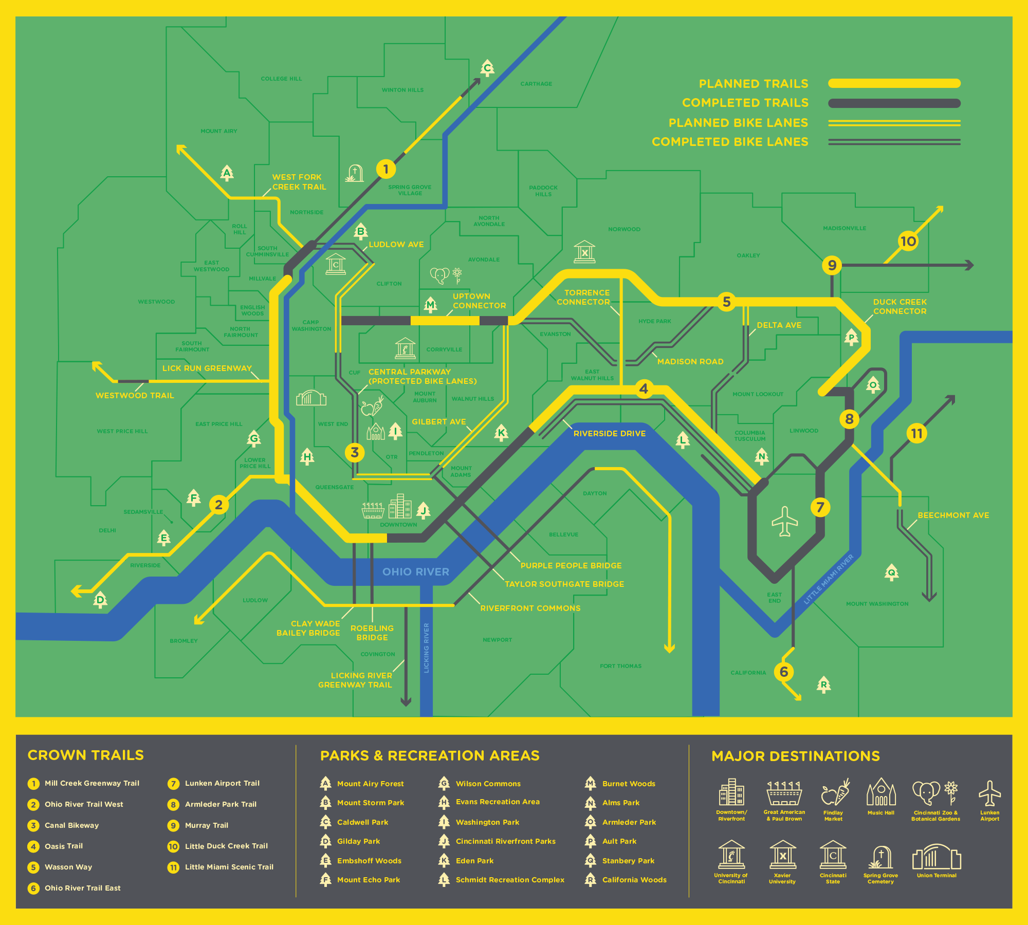
Ultimately the Wasson Way Trail falls under the auspices of the Cincinnati Riding Or Walking Network (CROWN). It is a vision for a 100+ mile active transportation network connected by a 30-mile separated trail loop around Cincinnati’s urban core. When complete, CROWN will connect at least 356,000 people in 49 neighborhoods to major destinations like employment centers, schools, parks, retail, recreation, and entertainment, according to Green Umbrella, the non-profit sustainability alliance that oversees Cincinnati’s trail systems.
At the heart of CROWN is a 30-mile trail loop that will link several trails that are currently in development by separate nonprofit organizations or government agencies. When complete, this unified vision will link existing trails like Little Miami Scenic Trail, Ohio River Trail East, Mill Creek Greenway Trail, Lunken Airport Trail, and Otto Armleder Trail to trails in development like Wasson Way, Oasis Trail, Ohio River Trail West, and Little Duck Creek Trail.
In nearby Indianapolis, the eight-mile Indianapolis Cultural Trail was initially met with vehement opposition when it was first conceived. Now, according to a study by the Indiana University Public Policy Institute, the trail is credited with increasing nearby property values by 148 percent, an increase of $1 billion in assessed property value. The average expected expenditure for all trail users is $53; out-of-town visitors exceed $100 in spending while using the trail.
I want this same economic and social impact for Cincinnati. To say I am excited at what is possible is an understatement. I am aware and engaged and willing to advocate for our expanded trail system. We don’t have to imagine if, we only have to imagine when. Stay tuned for more.
As a cyclist, I know the importance of living near these communities along our trails where we gather, play and eat. It improves our quality of life and strengthens our sense of community. If you are interested in purchasing a home for sale near our local trails, call me at 513.702.3419 or email [email protected]
CROWN Photo Map Credit: Green Umbrella